| Home | ||||||||||
|
|
||||||||||
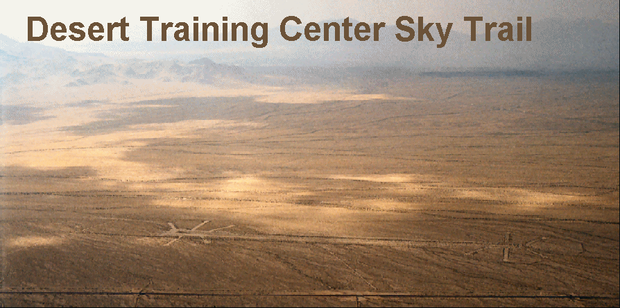
| Whether you are planning a visit from the Los Angeles area to the casinos and entertainment of Las Vegas or Laughlin, interested in military history, or just curious about the desert's secrets, you will find the views disclosed by this trail in the sky remarkable in their sweeping scope and lasting preservation. This DTC Sky Trail is an interpretive view of our nation's 1942 response to the Japanese and Nazi military aggression of World War Two (WWII). Aerial visitors will see the rock-alignments that still define the ghostly boundaries of the twelve divisional troop training campsites, airstrips, and other facilities, virtually unchanged since being laid down seven decades ago. It was April, 1942 when General George S. Patton, Jr. was tasked with creating a military training facility, the Desert Training Center (DTC), to prepare U.S. Soldiers for the Allied invasion of the deserts of North Africa, Operation Torch, launched November 8, 1942. 'Ole Blood and Guts' Patton, who wore ivory-handled revolvers on each hip, was a vigorous proponent of tank warfare, and I Armored Corps commander in charge of both the 1st and 2nd armored divisions, and was notorious for his skillful armor operations during training maneuvers. During the 1941 Louisiana Maneuvers, he dominated the action with daring tactics that outflanked and outclassed officers of the mock opposing forces by capturing their headquarters and commanders. Because George Patton had commanded the only American tank brigade to see action in the last World War, and had been an ardent advocate of armor ever since, he was chosen to create the DTC.  A flamboyant, some might term audacious, and undeniably successful military strategist, Patton surveyed the southwest from Yuma to Searchlight with his own personal 'Flying Jeep,' a little Stinson Voyager light, high-wing, three-seat aircraft. Doubtless, it was the aerial vantage point offered from Patton's airplane that facilitated such a grand vision for training armored troops. From that vantage point, Patton looked out upon the millions of acres of uninhabited desert and stated that: A flamboyant, some might term audacious, and undeniably successful military strategist, Patton surveyed the southwest from Yuma to Searchlight with his own personal 'Flying Jeep,' a little Stinson Voyager light, high-wing, three-seat aircraft. Doubtless, it was the aerial vantage point offered from Patton's airplane that facilitated such a grand vision for training armored troops. From that vantage point, Patton looked out upon the millions of acres of uninhabited desert and stated that:
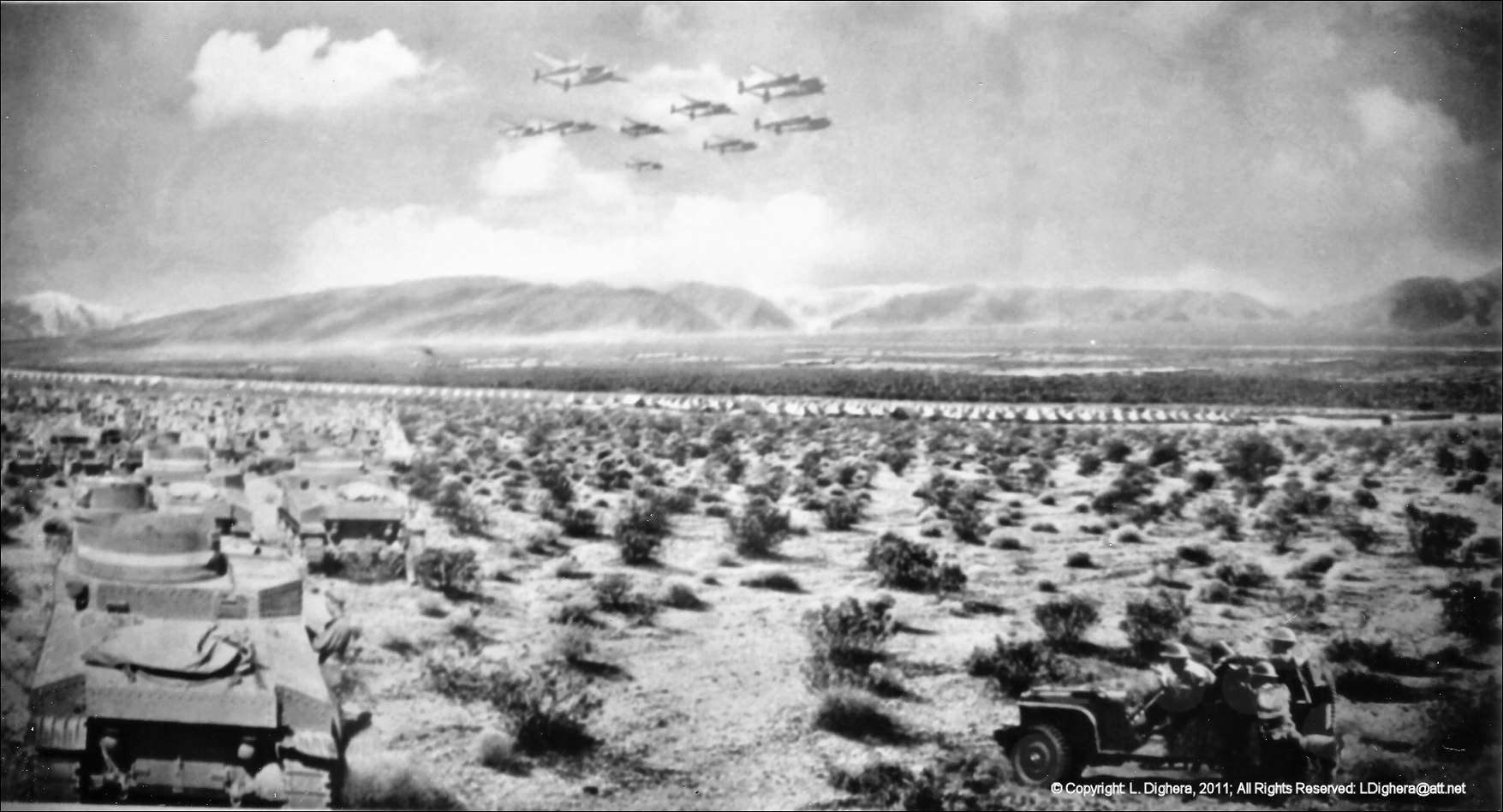
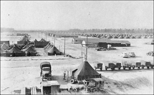
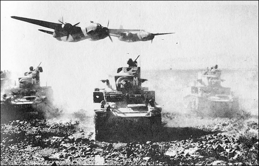
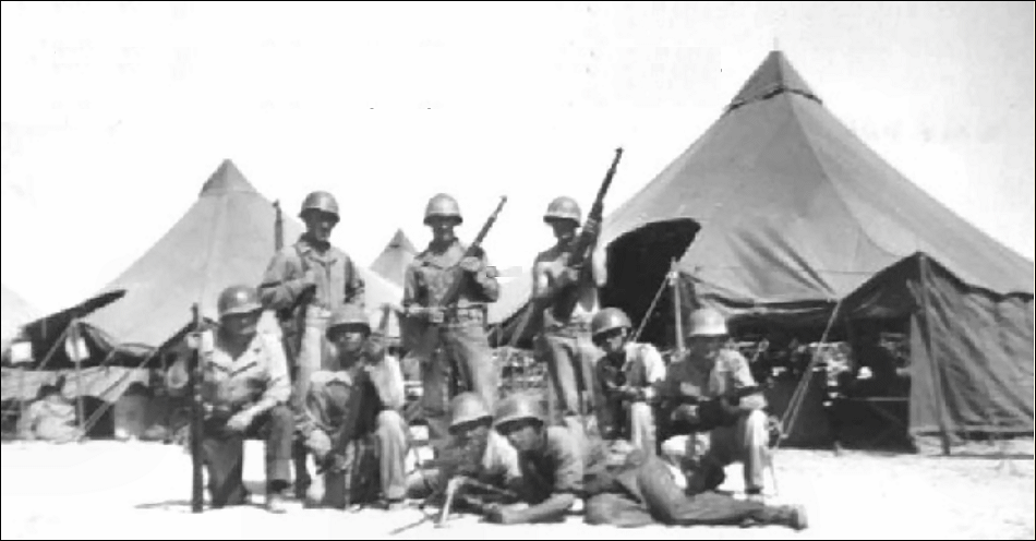
General Patton first learned to fly in an old Curtiss Jenny back in 1921 at Mitchell Field, Long Island. In the spring of 1942, Patton purchased 28 acres from Joseph Chiriaco for five dollars per acre and used the land as an airstrip adjacent to camp Young. Although General Patton sold his "Voyager" before he embarked for Casablanca in October, 1942, after the North African coast was secured, he had several Stinson "Flying Jeeps" shipped to him and used them in Tunisia, Sicily, and in Europe. In the fall of 1944, when his 3d Army had run right off its tactical maps in its dazzling dash across France, it was a light plane which carried a new set of charts to the stalled columns of armor. [2] Aware that tanks require vast space to maneuver, Patton's DTC, encompassed 18,000 square miles (an area about the size of the states of Vermont and New Hampshire combined), and remains today the world's largest military training facility. Due to the slow progress of erosion in the desert climate, and minimal human contact, significant vestiges of the twelve, one mile wide by three mile long, divisional campsites, many with their stone-and mortar religious altars, large relief maps, 500,000-gallon water reservoirs, and various other features, meet aerial visitors with their ghostly meticulous street layout after all these years since their construction. Each division consisted of 15,000 men and 400 M3 Stuart tanks. Even tank tracks are clearly visible today, notably in the area of Wiley's Well west of Blythe. Visitors on the desert floor will be awed by the intricate graphic rock-mosaic Company insignias still remain delicately placed in meaningful alignments today. The remains of the tactical aerodromes and three dimensional relief maps on which battle strategies were imparted to the recruits and veteran instructees, as they trained for mock battles in the Palen Pass region are still quite evident. With its enormous size and resulting wealth of historical cultural artifacts, the DTC today shouts its presence, despite those features' minimal height and arcane aspect. On these pages, you will find:
Should you be interested in becoming more involved with archeological preservation, interpretation, organization activities, or donations of physical labor, those subjects/topics are addressed under the Volunteering heading on the menu bar located at the top of every page. So, fly the DTC Sky Trail en route between LA and the Nevada resorts, and you're sure to arrive richer for the experience.
LOCATION: Mojave Desert, southern California [1] The Desert Training Center/California-Arizona Maneuver Area,1942-1944 HISTORICAL AND ARCHAEOLOGICAL CONTEXTS; Matt C. Bischoff Here is a video titled The Sands Of War produced in conjunction with the BLM, that shows actual historic footage of the DTC in operation and interviews of the personnel who served there. |
|||||||||||||||
|
March 20, 2013 By  The remnants of Camp Ibis, one of several camps established across 18,000 square miles of desert, are best viewed from the air. Photo courtesy Larry Dighera. The remnants of Camp Ibis, one of several camps established across 18,000 square miles of desert, are best viewed from the air. Photo courtesy Larry Dighera.
It has been a labor of love, one that Larry Dighera hopes will inspire fellow pilots to take a scenic excursion through history, and multiply. Dighera, 70, worked for 16 years, off and on, compiling a pilot’s guide and detailed history of the Desert Training Center created by Gen. George Patton in 1942 to prepare troops to fight in North Africa. While the structures are gone, there remains a network of roads, airstrips, and other visible vestiges of the sprawling center, geometric lines, and circles that stretch across a vast expanse of desert in southeast California and southwest Arizona. Dighera recently fired off press releases to several aviation media outlets, hoping to stir some interest in his own effort, and also to inspire others to follow suit.
“Somebody needs to get general aviation people excited about this,” Dighera said, adding that the nation is full of places that lend themselves to aerial tours. “Let’s get people making these things all over the place.” Dighera launched his effort with help from the creator of Anza-Borrego Desert State Park Sky Trail, another of the aerial attractions in easy reach for visitors to AOPA Aviation Summit 2012 in Palm Springs, Calif. Dighera collaborated with park service historians and secured a modest grant to support his online project, which includes docent scripts to be read aloud along the winding route between Laughlin/Bullhead International Airport and Chiriaco Summit Airport, home of the General Patton Memorial Museum. Dighera said the Blythe Intaglios—massive images carved centuries ago by native tribes—would make another fine sky trail of their own. “You can really appreciate them much better from the air,” Dighera said. “There should be a registry of them.” |
|||||||||||||||
 Wolf Aviation Fund Grant Recipient Wolf Aviation Fund Grant Recipient
|
|||||||||||||||
| Hits: [an error occurred while processing this directive] | Date of last edit: | ||||||||||||||
| © Copyright: L. Dighera, 2011; All Rights Reserved: LDighera@att.net | |||||||||||||||

 Larry Dighera, a commercial pilot with more than 900 hours in his logbook, spent many of them flying over and documenting the Desert Training Center. Photo courtesy Larry Dighera.