Same Trail, Three Different Names: How to Figure Out Which Path You're Actually Standing On
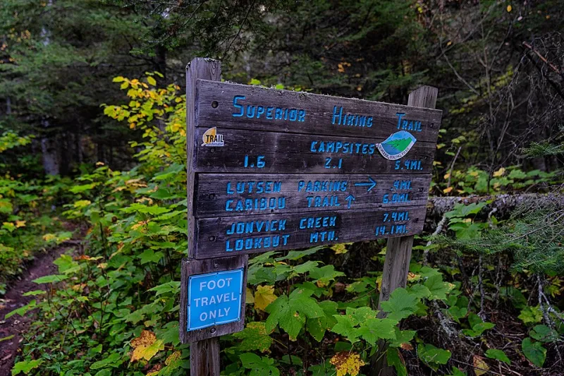
Photo: Tony Webster from Minneapolis, Minnesota, United States, CC BY 2.0, via Wikimedia Commons
You've done everything right. Downloaded the app. Cross-referenced the guidebook. Printed a backup map from the forest service website. And yet, somehow, you're standing at a trailhead sign that reads "Ridgeline Loop" while your phone is telling you you're at the start of the "Summit Connector Trail" — and the dog-eared paperback in your pack calls the whole thing the "Old Fire Road Route."
Congratulations. You've just stumbled into one of the most underappreciated headaches in American hiking: the trail name problem.
It's more common than most people realize, and it catches experienced hikers just as often as beginners. The same physical path through the woods can carry a half-dozen different names depending on which decade your source material comes from, who manages the land it crosses, and whether the local hiking club decided to rebrand things after a reroute nobody officially documented.
So why does this happen, and more importantly, how do you sort it out before you're standing at a fork in the trail with zero cell service and two conflicting directions?
Why Trails End Up With More Than One Name
The short answer: trails are old, land management is complicated, and nobody's in charge of the whole system.
Unlike street addresses, which are standardized and maintained by local governments, trail names in the US exist in a patchwork of jurisdictions. A single trail might cross land managed by the National Forest Service, a state park, a county open space district, and a private conservation easement — all within a few miles. Each of those entities has its own naming conventions, its own signage budget, and its own update schedule. When they don't coordinate, you get a trail that's called four different things on four different signs along the same route.
Then there's the history factor. Many trails in the American West and Appalachia have been in use for well over a century — sometimes as Indigenous travel routes, sometimes as logging or mining access roads, sometimes as fire management corridors. These paths accumulated names organically over generations. The "Miner's Cut" that a local community has used for 80 years might officially become the "Blue Ridge Access Trail" after a land transfer, but nobody's going back to update the handmade signs or the 2003 guidebook sitting on shelves at the outfitter in town.
Reroutes add another layer of confusion. When a trail gets moved — due to erosion, private land disputes, or ecological restoration — the new path often keeps the old name even though it no longer follows the original route. Meanwhile, some mapping platforms update immediately while others lag years behind. You can end up navigating toward a section of trail that physically no longer exists where your app says it does.
The Local Name Problem
Here's the thing about hiking communities: they name stuff. Constantly. Unofficially. Enthusiastically.
Local hiking clubs, trail running groups, and online communities regularly assign nicknames to trails that stick harder than anything on an official sign. These names often make perfect geographic sense — "The Notch," "The Wall," "Cardiac Hill" — and get passed down through word of mouth and forum posts until they're treated as gospel by anyone who hikes in the area regularly.
The problem surfaces when an out-of-towner shows up armed with official trail maps and asks a local for directions to a route by its formal name. Blank stares. "Oh, you mean the Widow-Maker?" Yes. Apparently that's what everyone calls it.
This is especially common in heavily hiked areas around cities like Denver, Portland, Salt Lake City, and Asheville, where trail culture runs deep and the local hiking community has been naming and renaming things independently of land managers for decades.
Cross-Border and Multi-Agency Headaches
Some of the messiest naming situations involve trails that cross between management boundaries. The Pacific Crest Trail handles this reasonably well because it's a federally designated National Scenic Trail with a dedicated association keeping things consistent. But most trails don't have that kind of institutional support.
Consider a trail that starts in a national forest, dips through a wilderness area, and ends in a state park. Each managing agency might name the segment within their jurisdiction differently. Hikers trying to piece together a through-route from multiple sources end up with a Frankenstein map of segment names that may or may not connect logically.
The White Mountains in New Hampshire are a classic example. The trail network there is managed by a mix of the White Mountain National Forest, the Appalachian Mountain Club, and various state agencies. The AMC has its own naming conventions, its own trail maps, and a long institutional history that doesn't always align perfectly with federal signage. It's navigable once you know the system — but it takes some learning.
How to Actually Decode Trail Names Before You Go
Okay, practical stuff. Here's how to avoid getting tripped up by the name game.
Start with the land manager's official source. Whatever agency manages the land — national forest, state park, BLM — find their official trail map first. This is your baseline. Everything else gets cross-referenced against it.
Use coordinates, not just names. GPS coordinates don't have naming disputes. When you're planning a route, grab the coordinates for the trailhead and any key junctions. That way, even if your app and your map disagree on names, you're navigating to actual points in space.
Check AllTrails and Gaia GPS together. These two platforms pull from different data sources and often disagree on names in interesting ways. When they match, you're probably on solid ground. When they don't, dig deeper before you go.
Search the local hiking community. A quick search on Reddit's regional hiking subs or local Facebook hiking groups will almost always surface the unofficial name situation for popular trails. If locals call it something different than the official name, you'll want to know that before you ask for directions at the trailhead.
Note the trailhead marker number. Many national forests and some state parks use numbered trailhead markers that are consistent across maps. If you can match the number, you're golden regardless of what the trail is called.
When in doubt, call ahead. A two-minute call to the ranger district office will save you an hour of confusion on the mountain. Rangers know their trail names cold, including the local nicknames and any recent reroutes.
The Bigger Picture
The trail naming problem is, in a lot of ways, a symptom of something actually kind of beautiful about American hiking culture: it's decentralized, community-driven, and deeply local. Trails accumulate names the way they accumulate cairns — organically, through use, through love, through people wanting to claim a little piece of a place they care about.
That's worth something. The "Widow-Maker" nickname isn't just confusing — it's also a piece of local character, a story waiting to be told.
But it's also worth sorting out before you're standing at a junction in the rain trying to figure out if the "Ridgeline Connector" your map shows is the same thing as the "Upper Fork Trail" on the sign in front of you.
Do the homework. Cross-reference your sources. And when you get out there and find that three names all lead to the same gorgeous summit view, you can appreciate the chaos for what it is — a reminder that these trails belong to everyone, and everyone's been leaving their mark on them for a long time.